
I attended the USGS-AASG sponsored 'DMT' meeting for the first time this year. I should have been attending this meeting for the last several years. This year, it was in Moscow, Idaho. I applied too late to give a talk, but forced myself on the audience anyway under the guise of a discussion.
Principal Take Home Messages (through the cynical filter of DrJerque):
1. Paper maps aren't dead, but they are dying, albeit slowly.
2. ESRI is coming to terms with the power and sway of Google Earth and kml
3. Existing USGS 24 k basemaps are no longer loved by all (and hated by some)
4. LiDAR kicks proverbial butt.
5. Some geologists still use Garmin 12xl GPS units....ouch!
6. Geotagging digital photos is still news to some.
7. Geologists are generally uninterested in carting computers around in the field.
8. Many state surveys still publish maps using graphic arts programs.
9. Archiving digital data is a major concern.
10. Geologic data standards are emerging. They need to be adopted.
Showing posts with label geologic mapping. Show all posts
Showing posts with label geologic mapping. Show all posts
Thursday, May 22, 2008


Saturday, February 23, 2008
Creating virtual context for geologic maps
Geotagging photos, diagrams, and map excerpts is an excellent way to aid in illustrating stratigraphic and geomorphic relations to colleagues. I have recently been doing field work in the Lake Mohave area and have photographed some key outcrops (see related posts here and here) that may be of interest to colleagues who are also trying to understand stratigraphic relations along the lower Colorado River. The slide show below includes those photos and illustrates another way to share geodata online.
Want to see the images on a map? Click this link and then you can view as online photo album or you can view it in Google Earth for the full effect. In cases where high resolution imagery is available, it only takes a little geo-imagination to comprehend the context of the image. No match for a field trip per se, but I think that it is one hell of a lot more illustrative than a discussion over the phone or showing a slide in a talk if you are simply trying to share information about a key outcrop.
I am currently experimenting with integrating several of my projects with online geotagged photo albums that include annotated stratigraphic diagrams, photos, and geologic map snippets. This is in the interest of developing quasi-interactive geologic data sets available for online evaluation, commentary, and review.
Want to see the images on a map? Click this link and then you can view as online photo album or you can view it in Google Earth for the full effect. In cases where high resolution imagery is available, it only takes a little geo-imagination to comprehend the context of the image. No match for a field trip per se, but I think that it is one hell of a lot more illustrative than a discussion over the phone or showing a slide in a talk if you are simply trying to share information about a key outcrop.
I am currently experimenting with integrating several of my projects with online geotagged photo albums that include annotated stratigraphic diagrams, photos, and geologic map snippets. This is in the interest of developing quasi-interactive geologic data sets available for online evaluation, commentary, and review.
Tuesday, December 11, 2007
Can you write your name with a mouse? (hint: no)

Digital geologic mapping has many advantages over 'analog' mapping. A really big one that is often ignored is the utility of a desktop digitizing tablet. Clicking away with the mouse along an elaborately shaped contact trace is bad for your wrist (and possibly, your brain) and falls far short of the speed and accuracy of using a pen. Just try writing your name in script with a mouse if you don't believe me. Most of us have been using writing implements in our hands since we were toddlers. I use a Wacom Intuos Tablet at home and at the office and can't imagine doing it any other way. You can program buttons on the pen and on the tablet to perform common program tasks to un-tether yourself from the mouse and the keyboard.
On the road and in the field I use a Tablet style notebook PC which allows you to use the pen directly on the screen.
A far better option for office use is a Pen Display:

This would be an extremely useful addition to any GIS / mapping oriented enterprise, no?
For the times when you just need paper but want to stay digital, there is a way. ADAPX has developed a digital pen and digital paper product that is rugged for the field. Check out the website: http://www.adapx.com/
Below is a snippet from their website (looks promising):
More Power to Paper with Digital Data CollectionUsing Capturx for ArcGIS, you get fully digitized GIS data from paper maps automatically. Because you don’t have to change the way you work, you eliminate the need for additional training on data collection, importing, and editing processes.
Capturx for ArcGIS is a powerful, easy-to-use, digital data collection solution that enables you to keep using paper maps. If you use ESRI ArcGIS® 9.2, the Capturx for ArcGIS extension is the ideal way to create, import, edit, share, and act on paper-based data in and between geographic information systems (GIS).
Capturx for ArcGIS 9.2 enables you to print out any ArcGIS map and feature legend on digital paper, and then make changes and annotations to the map in ArcGIS by simply writing on the printed map.
There is no need to modify your existing ESRI products because Capturx for ArcGIS can be used with any ArcGIS Desktop licenses, including ArcView®, ArcEditor™, or ArcInfo®, and is compatible with geodatabase feature classes, such as personal and enterprise ArcSDE®.
Download the datasheet for a complete list of key features.
Sunday, December 9, 2007
Making Polygons, 101
This is a huge topic for geologists using Arc software. Here are some basic tips (many more will be added over time):
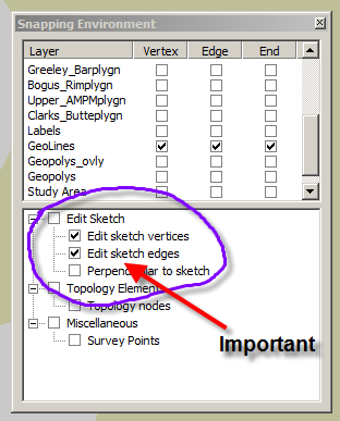
1. Make sure you have 'snapping' on. This is a two-tiered issue. Most importantly, make sure that you have two options selected in the 'Edit sketch' window. This will ensure that your draft (sketch) lines will snap. This is particularly relevant for sketching closed features.
2. Build topology for the geolines layer. This is simple. The most basic need is to enforce the 'no dangles' rule. This will flag sites where your lines overshoot or undershoot. Undershooting lines will not build polygons. Overshooting lines are unnecessary.
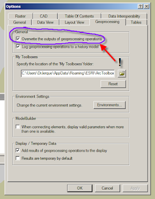
3. If you use ArcInfo, be sure to select the 'overwrite geoprocessing operations' option in the 'Options' menu. Doing this allows you to build polygons repeatedly into the same polygon layer, thus keeping only one layer and also retaining the layer's graphic attributes (i.e. colors and patterns. Note: In ArcEditor, you can only build polygons in ArcCatalog and you cannot build into an existing polygon layer as previously described.
1. Make sure you have 'snapping' on. This is a two-tiered issue. Most importantly, make sure that you have two options selected in the 'Edit sketch' window. This will ensure that your draft (sketch) lines will snap. This is particularly relevant for sketching closed features.

2. Build topology for the geolines layer. This is simple. The most basic need is to enforce the 'no dangles' rule. This will flag sites where your lines overshoot or undershoot. Undershooting lines will not build polygons. Overshooting lines are unnecessary.
3. If you use ArcInfo, be sure to select the 'overwrite geoprocessing operations' option in the 'Options' menu. Doing this allows you to build polygons repeatedly into the same polygon layer, thus keeping only one layer and also retaining the layer's graphic attributes (i.e. colors and patterns. Note: In ArcEditor, you can only build polygons in ArcCatalog and you cannot build into an existing polygon layer as previously described.

Thursday, November 8, 2007
Data Points in a Geodatabase
| Stations (site specific data) | |||
| [kind] O = generic observation | |||
| [kind] A = age | |||
| [kind] G = graphic data | |||
| [kind] R = sample sites | |||
| [kind] Y = analytical | |||
| Age categories (prefix 1) | |||
| a = Argon-Argon | |||
| r = radiocarbon | |||
| t = tephrochronologic | |||
| c = cosmogenic | |||
| Graphic data categories | |||
| p = photograph | |||
| s = sketch | |||
| Sample site categories | |||
| r = rock | |||
| s = sediment | |||
| t = tephra | |||
| Analytical categories | |||
| f = fluvial transport direction | |||
| g = fluvial gravel lag | |||
This is the structure of point data that we have built into the geodatabase for the Owyhee River mapping project. It covers all of the ground that is presently relevant to that project, but would need to be modified for a bedrock / structural map, for example.
Monday, October 29, 2007
Geologic Line Standards
OK, this is a long one, but I wanted to illustrate a geodatabase coding scheme for various line types used in geologic mapping with ArcGIS. This rather large subset and the related explanations is drawn from my mapping project on the Owyhee River so it is somewhat specific.
The codes are based on terminology in the new digital geologic map standards published by the FGDC. The underlying scheme is based on one developed by Hastings and Sylvester. The seemingly overly detailed list is based on degrees of certainty relative to two aspects of lines on a geologic map: 1. What sort of line it is and how certain you are about that; and 2. How well the line's location is known.
Each funny looking code is a combination of the following characters that account for a variety of lines and a variety of degrees of certainty about what and where they are:
Line Types [kind]
The codes are based on terminology in the new digital geologic map standards published by the FGDC. The underlying scheme is based on one developed by Hastings and Sylvester. The seemingly overly detailed list is based on degrees of certainty relative to two aspects of lines on a geologic map: 1. What sort of line it is and how certain you are about that; and 2. How well the line's location is known.
Each funny looking code is a combination of the following characters that account for a variety of lines and a variety of degrees of certainty about what and where they are:
Line Types [kind]
- C Contact
- X Fault
- R Rock body (marker bed or key bed)
- Z Scarp (as feature, not contact)
- M Morphologic
- B Boundary
- g generic
- l landslide
- i internal
- f fluvial
- v volcanic
- s sedimentary
- z scarp
- d depression
- m morphologic feature
- c certain
- q questionable
- a accurate
- x approximate
- c concealed
- i inferred
- uB Boundary—undifferentiated
- mB Boundary—mapsheet
- pB Boundary—property
- sB Boundary—scratch
- wB Boundary—water
- eB Boundary—exclusion
- gCca Contact—Identity and existence certain, location accurate
- gCqa Contact—Identity or existence questionable, location accurate
- gCcx Contact—Identity and existence certain, location approximate
- gCqx Contact—Identity or existence questionable, location approximate
- gCci Contact—Identity and existence certain, location inferred
- gCqi Contact—Identity or existence questionable, location inferred
- iCca Internal contact—Identity and existence certain, location accurate
- iCqa Internal contact—Identity or existence questionable, location accurate
- iCcx Internal contact—Identity and existence certain, location approximate
- iCqx Internal contact—Identity or existence questionable, location approximate
- sCca Incised-scarp sedimentary contact—Identity and existence certain, location accurate.
- sCqa Incised-scarp sedimentary contact—Identity or existence questionable, location accurate.
- sCcx Incised-scarp sedimentary contact—Identity and existence certain, location approximate.
- sCqx Incised-scarp sedimentary contact—Identity or existence questionable, location approx.
- ldCca Sag-pond or closed depression on landslide (mapped to scale)
- viCca Contact separating individual lava flows within same map unit—Identity and existence certain, location accurate
- viCcx Contact separating individual lava flows within same map unit—Identity and existence certain, location approximate
- viCqx Contact separating individual lava flows within same map unit—Identity or existence questionable, location approximate
- gXca Fault (generic; vertical, subvertical, or high-angle; or unknown or unspecified orientation or sense of slip)—Identity and existence certain, location accurate
- gXqa Fault (generic; vertical, subvertical, or high-angle; or unknown or unspecified orientation or sense of slip)—Identity or existence questionable, location accurate
- gXqx Fault (generic; vertical, subvertical, or high-angle; or unknown or unspecified orientation or sense of slip)—Identity or existence questionable, location approximate
- gXcc Fault (generic; vertical, subvertical, or high-angle; or unknown or unspecified orientation or sense of slip)—Identity and existence certain, location concealed
- kRca Key bed—Identity and existence certain, location accurate
- kRcx Key bed—Identity and existence certain, location approximate
- fZca Fluvial terrace scarp—Identity and existence certain, location accurate. Hachures point down scarp
- fZqa Fluvial terrace scarp—Identity or existence questionable, location accurate. Hachures point down scarp
- fZcx Fluvial terrace scarp—Identity and existence certain, location approximate. Hachures point downscarp
- lZca Head or main scarp of landslide—Active, sharp, distinct, and accurately located. Hachures point down scarp
- lZcx Head or main scarp of landslide—Inactive, subdued, indistinct, and (or) approximately located. Hachures point down scarp
- liZca Internal or minor scarp in landslide—Active, sharp,distinct, and accurately located. Hachures point down scarp
- liZcx Internal or minor scarp in landslide—Inactive, subdued, indistinct, and (or) approximately located. Hachures point down scarp
- vMca Flow lobe or lava-flow front—Identity and existence certain, location accurate. Hachures on side of overlying younger flow
- vMqa Flow lobe or lava-flow front—Identity or existence questionable, location accurate. Hachures on side of overlying younger flow
- vMcx Flow lobe or lava-flow front—Identity and existence certain, location approximate. Hachures on side of overlying younger flow
- vMqa Flow lobe or lava-flow front—Identity or existence questionable, location approximate. Hachures onside of overlying younger flow
- vMm Crest line of pressure ridge or tumulus on lava flow
Sunday, October 28, 2007
Geologic Mapping Toolbar in ArcGIS
 If you are limited to working with one screen, you will find it useful to make a custom toolbar to assist in compiling a geologic map. Simply right-click on the toolbar area and scroll through the list of available toolbars to the word 'customize', then make and name a new toolbar. You can then drag individual tools (commands) from the long lists of possibilities onto your new toolbar. In some cases, you will find that you have to drag the tool from an existing bar on your screen. The scale tool is an example that comes immediately to mind. The shot above is from my laptop.
Thursday, October 25, 2007
Geologic Time and Symbol Standards
It may interest you that there is a newly minted geologic time scale and implied color scheme recently released by the USGS and the AASG:
http://pubs.usgs.gov/fs/2007/3015/
Also note that there is a comprehensive document outlining a digital cartographic standard for geologic map symbolization:
http://ngmdb.usgs.gov/fgdc_gds/
At NBMG and other agencies, the implied color scheme in the timescale is largely unworkable in detailed maps of Tertiary and Quaternary deposits.
As for the symbology, this is an obvious standard for all geologic mappers and agencies to adopt.
http://pubs.usgs.gov/fs/2007/3015/
Also note that there is a comprehensive document outlining a digital cartographic standard for geologic map symbolization:
http://ngmdb.usgs.gov/fgdc_gds/
At NBMG and other agencies, the implied color scheme in the timescale is largely unworkable in detailed maps of Tertiary and Quaternary deposits.
As for the symbology, this is an obvious standard for all geologic mappers and agencies to adopt.
Subscribe to:
Posts (Atom)


