
Wednesday, February 27, 2008
The Wells, NV eq in Google Maps--More proof of the utter obviousness of online maps for Geologists
View Larger Map
This map is the effort of the Reno Gazette-Journal using USGS and UNR/NSL data. Shouldn't this map be embedded on on the NBMG website?


Saturday, February 23, 2008
Creating virtual context for geologic maps
Geotagging photos, diagrams, and map excerpts is an excellent way to aid in illustrating stratigraphic and geomorphic relations to colleagues. I have recently been doing field work in the Lake Mohave area and have photographed some key outcrops (see related posts here and here) that may be of interest to colleagues who are also trying to understand stratigraphic relations along the lower Colorado River. The slide show below includes those photos and illustrates another way to share geodata online.
Want to see the images on a map? Click this link and then you can view as online photo album or you can view it in Google Earth for the full effect. In cases where high resolution imagery is available, it only takes a little geo-imagination to comprehend the context of the image. No match for a field trip per se, but I think that it is one hell of a lot more illustrative than a discussion over the phone or showing a slide in a talk if you are simply trying to share information about a key outcrop.
I am currently experimenting with integrating several of my projects with online geotagged photo albums that include annotated stratigraphic diagrams, photos, and geologic map snippets. This is in the interest of developing quasi-interactive geologic data sets available for online evaluation, commentary, and review.
Want to see the images on a map? Click this link and then you can view as online photo album or you can view it in Google Earth for the full effect. In cases where high resolution imagery is available, it only takes a little geo-imagination to comprehend the context of the image. No match for a field trip per se, but I think that it is one hell of a lot more illustrative than a discussion over the phone or showing a slide in a talk if you are simply trying to share information about a key outcrop.
I am currently experimenting with integrating several of my projects with online geotagged photo albums that include annotated stratigraphic diagrams, photos, and geologic map snippets. This is in the interest of developing quasi-interactive geologic data sets available for online evaluation, commentary, and review.
Friday, February 1, 2008
Captain Obvious says: 'Geotag your photos'
Geotagging photos of key outcrops or geoscapes in the field is a very useful thing to do. To geotag a photo is to inscribe the digital file with geographic coordinates. Lots of people are doing it, but I fear that not enough geologists are.
All photo files from digital cameras have an exif header. This stands for 'exchangeable image file format' and it is the area where the file name, date, time, exposure, etc., info is stored. Recent interest in digital mapping has lead to the ability to add specific geographic information (i.e. geographic coordinates) to the exif header. This offers great potential to the field geologist. There are various ways to geo-tag a photograph. Up to now, my preferred way has been to use the free photo-sorting program Picasa (yup, a Google product...more on this at related post) wherein you can manually link a photo to a specific location by dragging it to the map. This works fine in many situations, but can be tedious. Over the last couple of days, I have experimented with a more automatic approach using a program called 'Geosetter' which very efficiently and easily geotags my field photos by directly linking their time-stamp with a corresponding GPS tracklog. Brilliant! In this way, you automatically create a geographically accurate set of field photographs. If you use Google Maps, Picasa, or Google Earth, you can then display the images on a base map of your choice.
Check out an example I made using a Picasa Web Album:
http://picasaweb.google.com/drjerque/SMNW
Once at the album, click the 'view map' link. Be sure to zoom way in using the satellite mode to fully appreciate how useful this application is. Furthermore, consider the fact that some of your field photos may be of great value to other geologists, botanists, historians, etc., at some point in time. By tagging them with key words, geo-tagging them, and making them available online, you may be doing a great service to other scientists. Burying them in a paper archive or on a CD somewhere does no good.
Note, you can use Picasa to geotag your photos one-by-one through a link with Google Earth, using a simple drag-and-drop procedure. At some point it is obvious that digital cameras will automatically stamp the file with the coords, but I think the linkage between digital photos and a GPS tracklog may be the best way to go.
All photo files from digital cameras have an exif header. This stands for 'exchangeable image file format' and it is the area where the file name, date, time, exposure, etc., info is stored. Recent interest in digital mapping has lead to the ability to add specific geographic information (i.e. geographic coordinates) to the exif header. This offers great potential to the field geologist. There are various ways to geo-tag a photograph. Up to now, my preferred way has been to use the free photo-sorting program Picasa (yup, a Google product...more on this at related post) wherein you can manually link a photo to a specific location by dragging it to the map. This works fine in many situations, but can be tedious. Over the last couple of days, I have experimented with a more automatic approach using a program called 'Geosetter' which very efficiently and easily geotags my field photos by directly linking their time-stamp with a corresponding GPS tracklog. Brilliant! In this way, you automatically create a geographically accurate set of field photographs. If you use Google Maps, Picasa, or Google Earth, you can then display the images on a base map of your choice.
Check out an example I made using a Picasa Web Album:
http://picasaweb.google.com/drjerque/SMNW
Once at the album, click the 'view map' link. Be sure to zoom way in using the satellite mode to fully appreciate how useful this application is. Furthermore, consider the fact that some of your field photos may be of great value to other geologists, botanists, historians, etc., at some point in time. By tagging them with key words, geo-tagging them, and making them available online, you may be doing a great service to other scientists. Burying them in a paper archive or on a CD somewhere does no good.
Note, you can use Picasa to geotag your photos one-by-one through a link with Google Earth, using a simple drag-and-drop procedure. At some point it is obvious that digital cameras will automatically stamp the file with the coords, but I think the linkage between digital photos and a GPS tracklog may be the best way to go.
Thursday, January 31, 2008
GPS Tracklogs for Dummies
In order to learn more about tracklogs on your GPS, simply break down and read the short manual that came with the unit. If your unit is more that 3 years old or uses more than 2 AA batteries, you should upgrade. One important consideration is upgrading to a unit that has a memory card slot. In that case, you will be able to store considerably more data. In the case of my Garmin GPS 60csx, interacting with the memory card is actually easier than interacting with the unit. Also, it automatically creates individual logs on a per day basis. Very handy.
Please, please (!) rid yourself of the belief that you need to turn the unit off all of the time to save batteries. Newer units can run for 2-4 days on a single set of batteries when turned on and off at the beginning and end of the field day. If you are worried about wasting batteries, then use rechargeable ones and move on, man. In order to maximize the value of the track log, the unit should remain on during the entire day (except during lunch, when you change batteries, or when you are mapping underground).
 A colleague at NBMG recently turned me on to a very handy program from the Minnesota Department of Natural Resources that easily converts GPS tracklogs and waypoints to shapefiles to use in GIS software. The program is called DNR Garmin and is extremely handy. Kudos to the author. The program can suck data right off the unit or can read from a gpx file. The image above is proof that it works.
Please, please (!) rid yourself of the belief that you need to turn the unit off all of the time to save batteries. Newer units can run for 2-4 days on a single set of batteries when turned on and off at the beginning and end of the field day. If you are worried about wasting batteries, then use rechargeable ones and move on, man. In order to maximize the value of the track log, the unit should remain on during the entire day (except during lunch, when you change batteries, or when you are mapping underground).
 A colleague at NBMG recently turned me on to a very handy program from the Minnesota Department of Natural Resources that easily converts GPS tracklogs and waypoints to shapefiles to use in GIS software. The program is called DNR Garmin and is extremely handy. Kudos to the author. The program can suck data right off the unit or can read from a gpx file. The image above is proof that it works.
Wednesday, January 30, 2008
GPS Tracklogs...use them.

I have spent the last 7 days doing field mapping in southern Nevada and fine-tuning some new and simple digital methods. Namely, using the GPS tracklog capability to document my progress, augment my note-taking, and the really cool application of automatic geotagging of field photos (look for related post about that).
GPS tracklogs: Why?
As a field geologist I am enamored with a tool that automatically knows my position in my map area. The handheld GPS is the most useful tool for geologists that has come around in a long time. If you don't use one and prefer to eyeball or triangulate your position the old fashion way, then grab your slide-rule, get on your horse and have at it.
Most of us already know that GPS is great to establish specific waypoints of key observations and sample locations, for example. A GPS tracklog is one step better in that it represents an accurate and complete record of an entire traverse over the course of a day, days, or weeks. Not only is this a useful method of documenting/demonstrating your progress in the field, but it also serves as an important complement to note taking. Once you have traversed a section of your field area, the tracklog will serve as a key reminder of your exact path. In your notes, if you often refer to what was crossed since the last formally recorded waypoint (i.e. SLO, or 'since last observation'), the track-log provides an accurate cartographic representation of exactly where you were since the previous observation (including backtracking to retrieve your forgotten rock hammer). Also, since the track-log can be tuned to record at very short intervals, you can even resort to recording the time of day to link field observations to your track log. Maybe that is too informal, but consider the point that this may be a way to make a quick observation at a time when you don't want to halt the traverse and formally record your position, etc., seeing that you are actually recording it anyway by recording the track log. Another short-hand approach relates to field photographs as described in a subsequent post.
Sunday, January 27, 2008
Do you manage your digital photos like a fool?
Are you the creator of an intricate directory structure in which you try to keep track of your digital photos? Have you actually saved multiple copies of a photo in order for it to be represented in relevant folders? I was once such a fool. For several years now, though, I have been using Picasa, a free and simple photo organizing program that allows you to tag your photos with key words instead of storing them in directories with key names. This turns out to be an extremely useful application if you have lots of digital photos. Tagging items with key words is superior to elaborate directory structures. Consider the following situation: You have a photo of a key outcrop in a specific map area that conveys multiple types of information. You can store that photo in a directory that is keyed to that map area and hope to remember that it also contains information relevant to other areas or geologic concepts.
Example from my work: Spirit Mtn. Northwest quad; Colorado River Sediment; Bullhead alluvium; erosional unconformity; sediment sample location.
What to do with this much information? By using tags in Picasa, I can store one copy of this image in a directory of my choice, but then tag it with all of those labels (likely shorthand versions like SMNW; Tcb; Unf; SSamp) so that all I have to do is search on the tag to find the image. Easy? Yes.
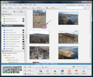
Picasa isn't the only program that does this, but I use it exclusively because I can so easily then link the photos with Google Maps, Google Earth, and any of my blogs (also, it is free). Be sure to check out the related post about geotagging photos and displaying them in a Picasa Web Album. The preceding screen-snag of the interface shows the basic layout. The circled area shows a compass rose icon indicating that the image has been geotagged and an arrow that indicates that it has been uploaded to a Picasa Web Album where the photos can be viewed in relation to the point from which they were taken in the field.
It should take you only 30 minutes to figure out how to use the program. Note that it will automatically search your computer for images and if offers some basic image editing functionality.
Example from my work: Spirit Mtn. Northwest quad; Colorado River Sediment; Bullhead alluvium; erosional unconformity; sediment sample location.
What to do with this much information? By using tags in Picasa, I can store one copy of this image in a directory of my choice, but then tag it with all of those labels (likely shorthand versions like SMNW; Tcb; Unf; SSamp) so that all I have to do is search on the tag to find the image. Easy? Yes.

Picasa isn't the only program that does this, but I use it exclusively because I can so easily then link the photos with Google Maps, Google Earth, and any of my blogs (also, it is free). Be sure to check out the related post about geotagging photos and displaying them in a Picasa Web Album. The preceding screen-snag of the interface shows the basic layout. The circled area shows a compass rose icon indicating that the image has been geotagged and an arrow that indicates that it has been uploaded to a Picasa Web Album where the photos can be viewed in relation to the point from which they were taken in the field.
It should take you only 30 minutes to figure out how to use the program. Note that it will automatically search your computer for images and if offers some basic image editing functionality.
Sunday, January 20, 2008
AZ State Geologist Blog Links
I have known that Lee Allison, the state geologist of Arizona, maintains a blog for some time now. Today I noticed that he collated a nice set of links to other geology blogs:
http://arizonageology.blogspot.com/2008/01/geoblogosphere.html
This list is a refreshing indication that I am not the only geologist that thinks this is a useful thing to do.
I also noticed that the AZGS is being subjected to some budget cuts and pressures for reorganization. Something is in the air.
http://arizonageology.blogspot.com/2008/01/geoblogosphere.html
This list is a refreshing indication that I am not the only geologist that thinks this is a useful thing to do.
I also noticed that the AZGS is being subjected to some budget cuts and pressures for reorganization. Something is in the air.
Subscribe to:
Posts (Atom)


