Monday, December 29, 2008

Gigapan is the Man!

Of all the interesting things I learned at AGU a week or so ago, the utility of the Gigapan system for understanding and illustrating geology sunk in the hardest.

Ron Schott of Ft. Hays State University gave an excellent presentation that made this particularly clear. The gigapan system is elegant in its simplicity and it offers an avenue for simply depicting the elegant complexity (good one, no?) of huge geological vistas and outcrops. It even has an application for looking at very small things in a big way. Check out Ron's blog for some details.

What is Gigapan? Well, it is a system for taking a panoramic photograph that is composed of many, many, small and detailed photographs. Presumably you have personally attempted to make your own pan photos, say, with a software package or with a built in camera function. Dare I say that you probably didn't wan't to try to stitch together more that 5, maybe 6 photos, right? You probably stopped at 3 or 4...like the image below:


The Gigapan cranks this technique up a giganotch by stitching together 10s and 10s of high-resolution images into a...wait for it...Gigapan. The image below is a faked example to illustrate the difference between your approach and the Gigapan approach:


So. Why would you want to do this? Well, for one thing, it is totally cool. For another, it offers an exceptionally efficient way for exploring a large outcrop or geoscape. Once you have taken this series of images, stitched them together, and uploaded the result to the Gigapan site, you can view it at all levels of resolution. In the case above, you can bask in the glory of the huge stack of intracanyon basalt flows on the Owyhee River. Then you can zoom in and look at the complicated cooling structures in great detail. Then you can zoom in and check out the contacts between the flows. While you are at it, you can check out the thin beds of gravels sandwiched between the basalts, etc. etc.

While you are looking at the details, you can pull out images that illustrate some of the aforementioned features. These high-res thumbnails can then be tagged and described for your colleagues to check out. They can then do the same thing and point out obvious stuff that you missed.

I already have my Gigapan gear en route. It works with my existing digital camera collection and is shockingly cheap. Stay tuned for some obvious examples of the application of this to geological studies. Also, stay tuned for the NeGIGAvada project...it is coming. Or should it be GIGAvada?

Monday, December 22, 2008

Abstract and Slides from Dr Jerque's recent talk

Digital Geologic Mapping and Integration with the Geoweb: The Death Knell for Exclusively Paper Geologic Maps
The combination of traditional methods of geologic mapping with rapidly developing web-based geospatial applications ('the geoweb') and the various collaborative opportunities of web 2.0 have the potential to change the nature, value, and relevance of geologic maps and related field studies. Parallel advances in basic GPS technology, digital photography, and related integrative applications provide practicing geologic mappers with greatly enhanced methods for collecting, visualizing, interpreting, and disseminating geologic information. Even a cursory application of available tools can make field and office work more enriching and efficient; whereas more advanced and systematic applications provide new avenues for collaboration, outreach, and public education. Moreover, they ensure a much broader audience among an immense number of internet savvy end-users with very specific expectations for geospatial data availability. Perplexingly, the geologic community as a whole is not fully exploring this opportunity despite the inevitable revolution in portends. The slow acceptance follows a broad generational trend wherein seasoned professionals are lagging behind geology students and recent graduates in their grasp of and interest in the capabilities of the geoweb and web 2.0 types of applications. Possible explanations for this include: fear of the unknown, fear of learning curve, lack of interest, lack of academic/professional incentive, and (hopefully not) reluctance toward open collaboration. Although some aspects of the expanding geoweb are cloaked in arcane computer code, others are extremely simple to understand and use. A particularly obvious and simple application to enhance any field study is photo geotagging, the digital documentation of the locations of key outcrops, illustrative vistas, and particularly complicated geologic field relations. Viewing geotagged photos in their appropriate context on a virtual globe with high-resolution imagery can be an extremely useful accompaniment to compilation of field mapping efforts. It can also complement published geologic maps by vastly improving their comprehensibility when field photos, and specific notes can be viewed interactively with them. Other useful applications include GPS tracking/documentation of field traverses; invoking multiple geologic layers; 3-D visualizations of terrain and structure; and online collaboration with colleagues via blogs or wikis. Additional steps towards collaborative geologic mapping on the web may also enhance efficient and open sharing of data and ideas. Geologists are well aware that paper geologic maps can convey tremendous amounts of information. Digital geologic maps linked via a virtual globe with field data, diverse imagery, historical photographs, explanatory diagrams, and 3-D models convey a much greater amount of information and can provide a much richer context for comprehension and interpretation. They can also serve as an efficient, entertaining, and potentially compelling mechanism for fostering inspiration in the minds of budding (and aging) geologists.

Check out this SlideShare Presentation:
Geofroth at AGU 2008
View SlideShare presentation or Upload your own. (tags: geology geotagging)

Monday, December 1, 2008

Captain Obvious Reviews his Transect

As a follow-up to recent and elementary post about how useful Google Earth is for field mapping, check out the traverse that I actually made:


Also, check out the online photo album that I created from the geotagged images shown on the snippet above:

Lower Walker River


If you don't think these technologies are useful, you may need to seek counseling.

Attribution ADD for you and me

Howdy Dummies. Are you like me? Do you get so wrapped up in mapping lines on high-res imagery that you fail to judiciously attribute them? You know, that 'oh man, I can just keep mapping this obvious contact until it disappears' feeling. Do you do the same with label points (you do use label points, right?)? Well, you can control your attention deficit by selecting a key option in Editor>Options interface:

Once you select the correct attribution option, you will be interrogated by the program as to what the attribute of the feature you just created is. Yes, you will have to make the call then. You really don't have time for that second, or third, or fourth sweep through the map do you? Do it right the first time. Be particularly judicious about your label points since those are much harder to formulate well after the fact.

I had no idea this option was available until fairly recently. If you knew of it, way to go. You are less of a dummy than I.

Wednesday, November 12, 2008

Captain Obvious Says: Google Earth is useful

File this one under the hilariously obvious. I am preparing for a 2-day outing for some reconnaissance along the range front of the Wassuk Range near Walker Lake. The piedmont there is an amazing plexus of massive, bouldery debris flow fans, multiple shorelines, and multiple Quaternary fault strands. It is an exceptional place to check out in real life and in Google Earth. In preparing my crap for the field, it dawned on me that instead of stupidly taking my computer in the field with a bunch of cached data, I could just print out some key perspectives on the areas I planned to visit. Duh. Despite being obsessed with hi-tech devices, I really do not like carrying a computer in the field. Also, I have never been one to enjoy using a stereoscope in the field, so this is an obvious solution.

If you have Google Earth Pro, you can save some nice high-res images (there are others ways to get them...) and doctor them up a bit for clarity and contrast. Check out the image below:


Thus, I will use this as one of my base images while mapping in the field. Isn't this obvious? Doesn't it look like a cool area to get paid to hike around in?

I am sure you know that you can overlay high-res geotifs in Google Earth if the existing base imagery does not meet your needs.

Tuesday, October 14, 2008

The Ultimate Digital Tool for Dummies and Luddites?


Imagine an ink pen that ~instantly converts your field notes into digital data. That's right. An ink pen that simply, and nearly instantly, converts all you have written into your field book into a digital notebook. There is one, I have tested it, I really like it, I have no reservations about recommending it. There are few reasons not to use it.

The pen and field book combo is made by Adapx. Through a complex combination of sensors in the pen and embedded patterns (Anoto pattern) in the paper (in this case, an actual Rite in the Rain field book), the pen's brain keeps a precise record of all the strokes it has made during the day. Once the day has ended, plug the thing into your computer and it uploads all the pages of notes. The latter, and most important step, requires that you use Microsoft OneNote software. This is not a dreadfully negative factor, however. The software is surprisingly useful.

The screen clipping below shows an example of the digital data pulled off of the pen. This (for what it is worth) does look precisely like my handwriting. The sample below is from a recent field stint on the Owyhee River. The embedded image and clean text were added later using simple tools in OneNote. (Read about OneNote here)

Also, OneNote can attempt to convert your handwriting to text. It does a fair job depending on your penmanship. At the very least, it gives you a decent start on converting your chicken-scratches.
The example above shows: 1. Field notes, 2. OneNote conversion, 3. Corrected note (with mistake, whoops)

Geologic mapperz stay tuned. This device is also designed to allow you to draft on to paper maps, yes paper maps, and automatically convert your analog mapping to digital mapping. It works with ArcGIS (must have the .NET framework installed) and has lots of promise. I will be testing this application in the field soon.

Notes: the pen and OneNote add-on cost me $300. Battery power is good for more than 1 day. The ink used by the pen is Rite in the Rain's proprietary ink. It gets a little thick in the cold. I would kill for a pencil, my preferred note taking device. Alas.

Friday, September 26, 2008

Masking the lake for a good stretch

If you make your geologic maps using ArcGIS and work with nicely detailed color imagery, then you already know how useful a stretch is. If not, check this previous posts for dummies:


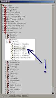
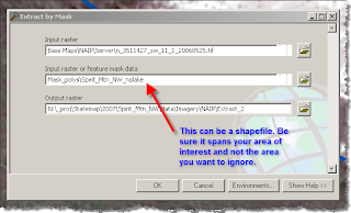
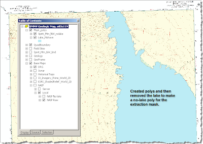
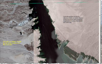
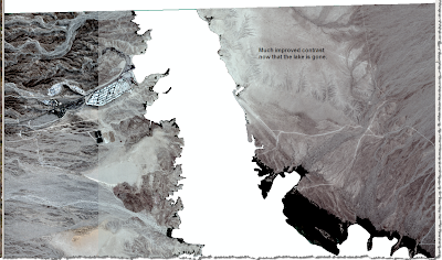
Now that you are back up to speed, I will share a simple trick I figured out by brute force that eliminates areas that may skew your stretch in an inconvenient way. Namely, large bodies of water. Right now, I am supposed to be finalizing mapping in the Spirit Mtn NW quad which includes parts of Nevada, Arizona, and Lake Mohave. Mapping along the lakeshore in the field is a joy; whereas compiling along the lakeshore is a pain in the neck...particularly when you use the standard deviation stretch restricted to the 'current display extent' which is usually the best option for contrast enhancement. The problem is caused by the black hole of lake pixels that dominate the statistics. The solution? Mask out the lake in a new raster using the 'extract' tool:


Here are the results from my current map area:

Before:

After:


Epilogue. Someone with considerably more knowledge in GIS than I once explained to me how I could do this with raster math. I screwed around with that and failed. After numerous scans through Arc Toolbox (haven't you scanned that stuff over and over looking for something?), I finally found some commands that sounded useful. Remember, this is digital geoscience for dummies.