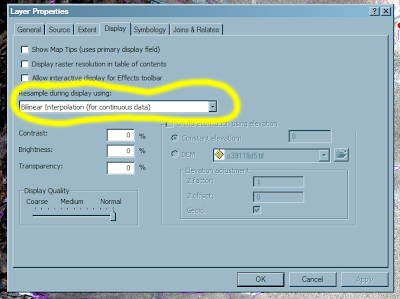
To get the most most out of your base imagery, you need to experiment with different image enhancement tools in Arc. The basic manipulations can be found under the 'display' and 'symbology' tabs found under 'layer--properties' (right-click on the layer of interest). To smooth the image without any negative effects, choose the 'bilinear interpolation' option and then click 'apply'. This will smooth your image in a visually satisfying way. Other resampling options may result in bothersome artifacts in the typical types of imagery that geologists use for mapping.
Stretch Your Imagery:
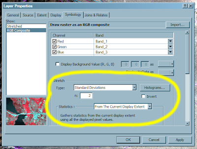
 Stretching your image can create levels of contrast and color balance that you will appreciate. For details, consult a remote sensing textbook. For now, just accept the fact that you can vastly improve an image's appearance by applying a standard deviation stretch to your data. Start with n=2 and experiment with increasing and decreasing this value. Also, if you limit the stretch statistics to the 'Current Display Exent' you will get ~local results that typically improve the contrast of the image. This will vary with the absolute range of values present in the current display. Experiment with other stretches.
Both of these enhancements are useful for b/w DOQQs, color DOQQS, and Quickbird data among (presumably) all other remotely sensed base (photo-like) imagery. It is not useful for DRGs.

No comments:
Post a Comment