Thursday, January 31, 2008

GPS Tracklogs for Dummies

In order to learn more about tracklogs on your GPS, simply break down and read the short manual that came with the unit. If your unit is more that 3 years old or uses more than 2 AA batteries, you should upgrade. One important consideration is upgrading to a unit that has a memory card slot. In that case, you will be able to store considerably more data. In the case of my Garmin GPS 60csx, interacting with the memory card is actually easier than interacting with the unit. Also, it automatically creates individual logs on a per day basis. Very handy.

Please, please (!) rid yourself of the belief that you need to turn the unit off all of the time to save batteries. Newer units can run for 2-4 days on a single set of batteries when turned on and off at the beginning and end of the field day. If you are worried about wasting batteries, then use rechargeable ones and move on, man. In order to maximize the value of the track log, the unit should remain on during the entire day (except during lunch, when you change batteries, or when you are mapping underground).

A colleague at NBMG recently turned me on to a very handy program from the Minnesota Department of Natural Resources that easily converts GPS tracklogs and waypoints to shapefiles to use in GIS software. The program is called DNR Garmin and is extremely handy. Kudos to the author. The program can suck data right off the unit or can read from a gpx file. The image above is proof that it works.

Wednesday, January 30, 2008

GPS Tracklogs...use them.


I have spent the last 7 days doing field mapping in southern Nevada and fine-tuning some new and simple digital methods. Namely, using the GPS tracklog capability to document my progress, augment my note-taking, and the really cool application of automatic geotagging of field photos (look for related post about that).

GPS tracklogs: Why?

As a field geologist I am enamored with a tool that automatically knows my position in my map area. The handheld GPS is the most useful tool for geologists that has come around in a long time. If you don't use one and prefer to eyeball or triangulate your position the old fashion way, then grab your slide-rule, get on your horse and have at it.

Most of us already know that GPS is great to establish specific waypoints of key observations and sample locations, for example. A GPS tracklog is one step better in that it represents an accurate and complete record of an entire traverse over the course of a day, days, or weeks. Not only is this a useful method of documenting/demonstrating your progress in the field, but it also serves as an important complement to note taking. Once you have traversed a section of your field area, the tracklog will serve as a key reminder of your exact path. In your notes, if you often refer to what was crossed since the last formally recorded waypoint (i.e. SLO, or 'since last observation'), the track-log provides an accurate cartographic representation of exactly where you were since the previous observation (including backtracking to retrieve your forgotten rock hammer). Also, since the track-log can be tuned to record at very short intervals, you can even resort to recording the time of day to link field observations to your track log. Maybe that is too informal, but consider the point that this may be a way to make a quick observation at a time when you don't want to halt the traverse and formally record your position, etc., seeing that you are actually recording it anyway by recording the track log. Another short-hand approach relates to field photographs as described in a subsequent post.

Sunday, January 27, 2008

Do you manage your digital photos like a fool?

Are you the creator of an intricate directory structure in which you try to keep track of your digital photos? Have you actually saved multiple copies of a photo in order for it to be represented in relevant folders? I was once such a fool. For several years now, though, I have been using Picasa, a free and simple photo organizing program that allows you to tag your photos with key words instead of storing them in directories with key names. This turns out to be an extremely useful application if you have lots of digital photos. Tagging items with key words is superior to elaborate directory structures. Consider the following situation: You have a photo of a key outcrop in a specific map area that conveys multiple types of information. You can store that photo in a directory that is keyed to that map area and hope to remember that it also contains information relevant to other areas or geologic concepts.

Example from my work: Spirit Mtn. Northwest quad; Colorado River Sediment; Bullhead alluvium; erosional unconformity; sediment sample location.

What to do with this much information? By using tags in Picasa, I can store one copy of this image in a directory of my choice, but then tag it with all of those labels (likely shorthand versions like SMNW; Tcb; Unf; SSamp) so that all I have to do is search on the tag to find the image. Easy? Yes.


Picasa 
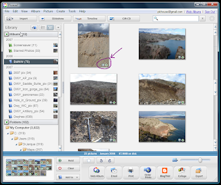
isn't the only program that does this, but I use it exclusively because I can so easily then link the photos with Google Maps, Google Earth, and any of my blogs (also, it is free). Be sure to check out the related post about geotagging photos and displaying them in a Picasa Web Album. The preceding screen-snag of the interface shows the basic layout. The circled area shows a compass rose icon indicating that the image has been geotagged and an arrow that indicates that it has been uploaded to a Picasa Web Album where the photos can be viewed in relation to the point from which they were taken in the field.

It should take you only 30 minutes to figure out how to use the program. Note that it will automatically search your computer for images and if offers some basic image editing functionality.

Sunday, January 20, 2008

AZ State Geologist Blog Links

I have known that Lee Allison, the state geologist of Arizona, maintains a blog for some time now. Today I noticed that he collated a nice set of links to other geology blogs:

http://arizonageology.blogspot.com/2008/01/geoblogosphere.html

This list is a refreshing indication that I am not the only geologist that thinks this is a useful thing to do.

I also noticed that the AZGS is being subjected to some budget cuts and pressures for reorganization. Something is in the air.

Saturday, January 19, 2008

Requiem for paper maps, continued.

I think it is important to consider the types advances shown below and their promulgation into all levels of popular culture as clear indications of transformation in the expectations of end users of maps of all kinds. The advances in 3D representation are particularly interesting.

Here are some links I found today that indicate various types of transformation in communicating and displaying geographic data:

Check this link to a recent article and video in the Wall Street Journal: Digital Maps

Check out this new GPS unit from Garmin: The 'Colorado'. This looks like a promising foray into the type of interface that would be particularly useful for geologists. I have been experimenting with a variety of gps field tools (palmtop computer, Panasonic toughbook) but I have the fewest qualms about simply using my Garmin 76csx. This new unit looks great to me.
Yes, I do want one....however, $599.


Follow the link below to see a lengthy presentation about virtual volcanology in Google Earth. The author is a strong proponent of using Google Earth in Geoscience, and presented at AGU's virtual globe session. The presentation is a bit long, but it reinforces the obvious point that Google Earth is an essential tool for geologists. Its potential for teaching geology is vast. The instructional value of you tube also comes across in this context. Stay tuned to this blog for an example of the value of new online presentation software as well.

Virtual Volcanology

Friday, January 11, 2008

Topofusion is Useful...check it out.

Topofusion is a very useful program that you may want to check out. It provides a handy and efficient interface for rapidly downloading and tiling topographic maps of a large range of scales, orthophotos, Landsat data, and other sources. The base images are collected from internet map servers as a background operation while you pan the program window. You can easily upload GPS waypoints and tracks into the program and quickly evaluate the position on a topo base that you are familiar with.

I used Topofusion to create this map which shows all of my foot traverses in my Owyhee River study area over the summer and fall. The program offers some interesting routines that generalize complex tracks to create a trail network that helps reduce irregularities and redundancies in GPS tracklogs. This is an easy way to show your progress in field reconnaissance if you are so inclined (yep, I am).

Recently, I used Topofusion to pan through a series of topo maps of the western United States to further investigate the geomorphology (and learn the names) of some very interesting geologic features I had seen on various airplane trips this last year (see related Google Map and Geotagged photo album). Topofusion was the best way to do this quickly because it provides very rapid access to all the detailed topo maps of the US which include many more place names than you can find in, say, Google Earth.

Wednesday, January 9, 2008

Reno-Gazette Journal makes good use of Google Maps

The hapless residents of Fernley, Nevada were recently struck by a flood of entirely human design when the canal that deprives Pyramid Lake of water failed into their neighborhood on an extremely cold and snowy morning.

Authors at the RG&J put together a Google Map to illustrate the effects of the flood. They also recently put one together to show snow and road conditions in the Lake Tahoe area. Good move.


View Larger Map

Sunday, January 6, 2008

Virtual Field Trip with Geo-tagged Photos

Another option for providing spatial context for geologically oriented photographs is to geotag them in an online photo album that links to a map. Here is an example made using Picasa, a very handy (free) photo organizing program that can geotag photos for viewing in Google Maps or Google Earth: Geotagged Photo Example

Very Basic Example of a Virtual Field Trip

As I have mentioned in previous posts, Google Map's 'My Maps' feature offers a way to very quickly develop some interesting maps that incorporate images and commentary. This is the most basic application. It is possible to make the interface considerably more elaborate with additional coding using an API--application programming interface. The example below is one that I put together with a few hour's work with photo editing and Google Maps. It highlights some scenic points on recent flights between Reno, Vegas, and Oklahoma City (although the scenery ends near Albuquerque). The potential for this to highlight geologic features of Nevada is obvious, no? It can even be made very technical to share with other scientists. I made mine for fun, but it could be augmented considerably with text on history and geology along with relevant links.


View Larger Map